China says it has never recognised the Union Territory of Ladakh and has called India’s decision to standardise 28 place names there “illegal and invalid”. Beijing’s foreign ministry responded on 13 October, eleven days after India’s Ministry of Home Affairs placed the names on official Survey of India maps.
India’s Standardisation of 28 Place Names in Ladakh
On 2 October, the Ministry of Home Affairs (MHA) said the Centre, in consultation with the Union Territory of Ladakh, had identified 28 places and features “by standard place and feature names on the official map of Survey of India”. The ministry said formally marking them on the map would help the public recognise the locations accurately and become more aware of them.
The list covers peaks, mountain ranges, passes, glaciers, valleys, rivers, lakes and land areas. Reported entries include Zorawar Peak, Kanishka Peak, Atisha Giri, Martand Giri, Chapchingal Pass, Shachmirk Pass, Guru Rinpoche Lake and the Yangpa River. Several names honour Buddhist teachers and translators, among them Rinchen Zangpo, Marpa Lotsawa and Milarepa. Defence-focused outlets also reported that Gogra and Hot Spring, two friction points in the 2020 standoff along the Line of Actual Control (LAC), are on the list, and some reports say it includes areas under Chinese control.
Official Survey of India maps carry real administrative weight. Government bodies rely on them for district planning, disaster management, census operations and infrastructure projects, which is why a naming exercise is never merely cosmetic. Ladakh has been a Union Territory since 31 October 2019, when it was separated from the former state of Jammu and Kashmir.
The move also follows a template set two months earlier. On 7 August, India standardised the names of 27 locations in Arunachal Pradesh on the same maps, widely read as a direct answer to Beijing’s renaming campaign there.
Beijing’s Response: Rejection of the Measure as Illegal and Invalid
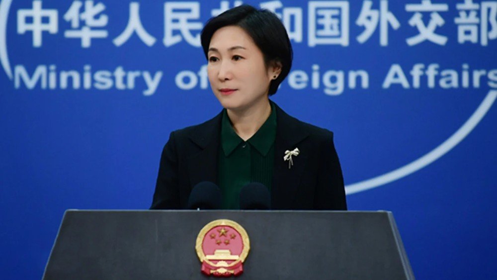
At a regular briefing in Beijing on Tuesday 13 October, foreign ministry spokesperson Mao Ning was asked about the MHA announcement. She said China has never recognised the so-called Union Territory of Ladakh, which she described as unilaterally and illegally established by India, and that it firmly opposes the publication of what she called “so-called standard names”.
Mao added that the move is illegal and invalid and cannot change the fact that the relevant areas in the western sector of the China-India boundary have always belonged to China. State news agency Xinhua carried the same position.
The line is not new. Beijing objected when Ladakh became a Union Territory in 2019, with a foreign ministry spokesperson at the time saying China did not recognise it. Indian officials answered then that historical records contradict the claim. They pointed to Tibetan, Sikh-era and British documents, including the 1684 Treaty of Tingmosgang, which treated Ladakh and Tibet as separate entities.
New Delhi has since replied. On Tuesday, the same day as Mao’s briefing, the Ministry of External Affairs said Ladakh is an “integral and inalienable part of India” and that no denial from Beijing can change that. It mirrors the August pattern: after China criticised the Arunachal naming exercise, the Ministry of External Affairs rejected the objection within days, calling Arunachal Pradesh an inalienable and integral part of India. Indian commentary on the latest statement has been equally blunt, arguing that Beijing’s objections cannot undo an Indian administrative decision on the territory currently under Indian control.
Historical Context: The Unresolved India–China Boundary
The two countries share a boundary of roughly 3,488 kilometres that has never been fully delimited. It is usually divided into three sectors: the western sector in Ladakh, the middle sector along Himachal Pradesh and Uttarakhand, and the eastern sector along Arunachal Pradesh, where India recognises the 1914 McMahon Line and China does not.
In the west, the dispute centres on Aksai Chin. India says China has occupied around 38,000 square kilometres of Indian territory in Ladakh for six decades. India also rejects the 1963 China-Pakistan boundary agreement, under which Pakistan ceded 5,180 square kilometres of the Shaksgam Valley to China. China, for its part, calls the eastern sector “Zangnan” or South Tibet and claims it as its own.
The flashpoints are well known:
- 1962: a month-long border war ends with Chinese forces holding Aksai Chin.
- 1993 and 1996: agreements on peace and confidence-building along the LAC.
- 2017: a 73-day standoff at Doklam, near the Bhutan tri-junction.
- June 2020: a clash in the Galwan Valley kills 20 Indian soldiers and begins a prolonged military confrontation in eastern Ladakh.
- October 2024: a patrolling arrangement eases the standoff at Depsang and Demchok.
Talks have continued since. The 36th meeting of the Working Mechanism for Consultation and Coordination on India-China Border Affairs took place in New Delhi in early August 2026, just before India published its Arunachal list.
The Cartographic Contest: Reciprocal Naming Practices
Beijing’s renaming campaign. Since 2017, China’s Ministry of Civil Affairs has released six batches of “standardised” Chinese names for places in Arunachal Pradesh, totalling 112 names by April 2026. The sixth list, published on 10 April, contained 23 names. India’s Ministry of External Affairs rejected it two days later, accusing Beijing of “mischievous attempts” to assign fictitious names, and warned that such steps undermine efforts to stabilise relations. On 14 April, spokesperson Guo Jiakun replied that naming places in the region was entirely within China’s sovereignty, while insisting Beijing’s policy of improving ties was unchanged.
India’s reciprocal measure in Arunachal Pradesh. On 7 August, the MHA placed 27 locations in Arunachal Pradesh on Survey of India maps. They included 21 land areas, four mountain passes (Dzo La, Riza La, Pukur La and Thag La), a lake called Sambho Sarovar and the Sher-e-Thapa Memorial. China called the exercise illegal, null and void, and Chinese experts described it as self-deception that runs against the improving momentum in relations.
Extension to the western sector. The 2 October announcement extends the same approach to the western sector. What Beijing calls “illegal acts”, India describes as routine “standardisation” of official cartography. Delhi’s argument is simple: a Union Territory it administers, and whose maps it publishes, needs consistent names.
Parallel administrative measures. China’s decision at the end of 2024 to create two new counties in Hotan Prefecture, parts of which India says fall within Ladakh, drew a “solemn protest” from New Delhi. The government told Parliament it had never accepted China’s occupation of Indian territory in the area and that the new counties would not legitimise it. Each side therefore treats the other’s administrative and cartographic steps as unlawful, and each insists its own are sovereign prerogatives.
Ladakh’s Historical Ties with Tibet
Ladakh shares deep historical, religious and cultural ties with Tibet, which is part of China today, rather than mainland India. Ladakh and Tibet shared close trade, cultural and spiritual links for centuries across the Himalayas, before modern borders and political separation took place in the 20th century. Ladakh follows Tibetan Buddhism and speaks Ladakhi (Bhoti), a Tibetic language written in the Tibetan script. Major religious centres like Hemis, Thikse and Lamayuru share architectural, monastic and spiritual lineages directly with Tibetan traditions.
Strategic Implications for India–China Relations
Names on a map change nothing on the ground in Ladakh, where the practical questions remain patrolling rights, buffer zones and troop levels. Their value is legal and political. Standard names on official maps strengthen each side’s documentary record, feed into administration and, over time, shape how international audiences see a territory.
The timing is awkward for both capitals. Ties have been recovering since the 2024 patrolling arrangement, and both governments describe the relationship as stable. Yet every renaming batch, and now each counter-list, tests that claim. India has warned that Beijing’s naming of Arunachal places could derail normalisation, while Chinese commentators say India’s lists complicate the handling of border issues.